Streambank Remediation Following Flood Impacts
Elaman Creek
A consortium of partners tackling Mary River flood recovery and riverine restoration, including Burnett Mary Regional Group (BMRG), Mary River Catchment Coordinating Committee (MRCCC) and Alluvium Consulting, recently completed three major streambank remediation sites on the Mary River and its tributaries.
Three of the five project sites have been completed as part of phase one:
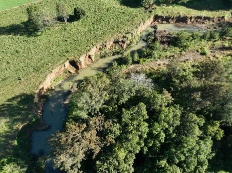
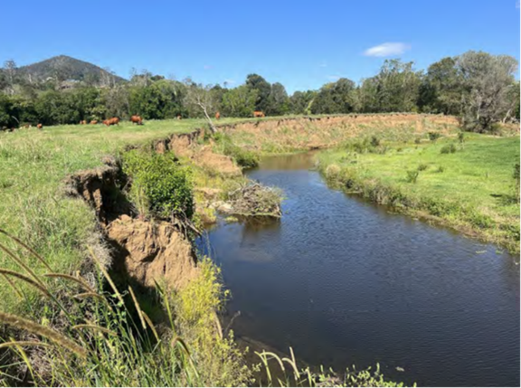
Elaman Creek reach: Located along Elaman Creek in the Upper Mary River Catchment, this site experienced significant bank erosion due to meander migration during the 2022 floods, resulting in streambanks of 3-5 meters high.
Obi Obi Site: Situated about 11.5 km upstream from its confluence with the Mary River, this site had a 3-6-meter-high left bank consisting of exposed sandy soil.
Elliot Site: Located in the Kenilworth region, this site featured an unstable vertical bank 4-6 meters high, stretching along 400 metres of stream.
Elaman Creek before works
The Mary River Streambank Remediation Program has helped repair areas of significant erosion and sediment loss by stabilising banks and adding deep rooted native begetation back into the system. This program is supported through the jointly funded Commonwealth-state Disaster Recovery Funding Arrangements (DFRA).
Disaster Recovery Funding Arrangements (DRFA) are triggered in response to severe weather events, and in this case activated from the event in Queensland during 2021-2022, which led to unprecedented rainfall (1800mm) and Gympie’s highest flood peak since 1893. BMRG were successful in their grant application for recovery assistance in the Mary River catchment under the DRFA.
Elaman Creek after completion
The Mary River and its tributaries provide critical habitat for threatened species, including the Mary River Turtle, Australian Lungfish, Mary River Cod, White-Throated Snapping Turtle, and Platypus. The project sites selected had been impacted with significant erosion of the banks. Riverine restoration efforts aim to enhance streambank stability, reduce sediment loss, and re-establish riparian vegetation, benefiting both plants and animals in the Mary River Catchment and the downstream Great Sandy Strait and Great Barrier Reef.
This program of work has identified five remediation sites selected through technical assessments and advanced tools like LiDAR (Light Detection and Ranging) to identify critical sources of fine sediment. Aircraft-mounted LiDAR sensors detect surface reflections, providing accurate details on changes in land, vegetation, and infrastructure. By comparing data between 2014 and 2022, a multi-temporal 3D Digital Elevation Model summarising erosion and deposition at the sites was built. Subsequently, tectonic geotechnical and environmental engineers conducted a geotechnical investigation involving borehole drilling and slope stability analysis. These assessments informed the design solutions for the sites.
Obi Obi site before works
Design solutions employed a combination of revegetation and engineering methods. Engineering methods included reprofiling steep banks to a 1V:3H gradient to facilitate vegetation growth. Timber pile fields were used to reduce shear stress in lower bank zones, encouraging sediment deposition and creating favourable conditions for plant establishment. Root-ball logs were installed to disrupt river flow, lower near-bank velocity, and provide habitat for aquatic life, while rock armouring protected the pile fields from scour.
Revegetation is crucial for the long-term success of these interventions. The pile fields gradually disintegrate over a 10–15-year period, ensuring natural bank stability and erosion protection during this time. This allows time for revegetation to establish, with plant roots gradually taking over from the piles to stabilise the banks. These techniques have been successfully used in previous Mary River restoration projects and have proven resilient during the 2022 floods.
Elliot Site: Pile Field rock, rock bags & rock armouring
The two remaining sites are currently undergoing works as part of this program, with full project completion expected by mid-2025. The completed sites will be maintained for an additional year after revegetation activities, which will involve essential watering and measures to reduce the risk of weed infestation.
To minimise impacts on wildlife breeding areas during restoration, detailed fauna surveys were conducted before work commenced, and fauna spotters monitored activity on-site regularly. Actions taken at the completed sites included relocating a White-Throated Snapping Turtle nest and removing Pardalote nesting holes before nesting occurs.
This collaborative effort demonstrates the importance of integrating engineering and environmental solutions to restore and protect vital riverine ecosystems. The ongoing commitment to maintaining and monitoring these sites, provided by MRCCC, ensures the long-term success and resilience of the Mary River catchment and its inhabitants.


